
A Red Flag Warning is in effect for portions of western Nevada and northeastern California, where thunderstorms, strong winds, and lightning are combining to create dangerous fire weather conditions Thursday.
The National Weather Service in Reno says thunderstorms are expected to develop Thursday afternoon, bringing gusty outflow winds up to 50 mph, lightning, and small hail. The strongest storms could produce hail up to 1 inch in diameter.
The National Weather Service has issued the Red Flag Warning from 1 p.m. to 10 p.m. Thursday for the Sierra Front, covering Carson City, Douglas, Storey, Southern Washoe, Western Lyon and far Southern Lassen counties, along with Alpine, Northern Mono, Southern Lyon and Western Mineral counties.
Forecasters expect a mix of wet and dry thunderstorms, though some uncertainty remains over how widespread the storms will be. Isolated dry lightning is still possible.
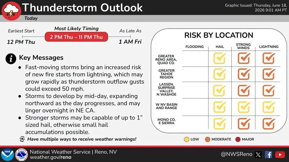
Officials warn that lightning could ignite new fires, while strong and erratic thunderstorm outflow winds may cause any new ignitions to grow rapidly in size and intensity before first responders can contain them.
Forecasters added that increasing thunderstorm chances and fast storm motions could raise the threat of new lightning-caused fire starts as the week winds down.
Beyond Thursday’s Red Flag Warning, a Fire Weather Watch has also been issued for parts of northeastern California and far northwestern Nevada on Friday.
Residents are encouraged to have multiple ways to receive weather warnings, avoid activities that could create sparks near dry vegetation, and follow local fire restrictions. For the latest forecasts, watches and warnings as conditions change, stay with 2 News Nevada.


Leave a Comment